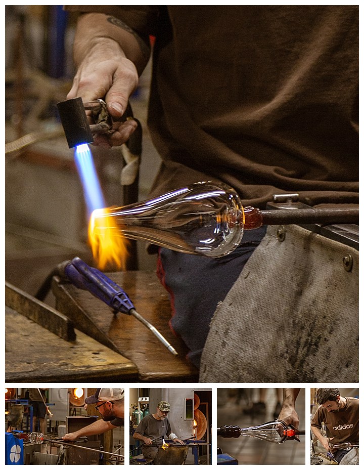
After we completed Loren’s workshop, we started to explore New England on our own. I did some rudimentary glass blowing as a hobby many decades ago while in high school, so I often like to visit working glass blowing shops when we are in the area. Simon Pearce is a glass factory in Woodstock, Vermont, and though they only had a couple people working, the scene was interesting, especially the waterfall in the back.
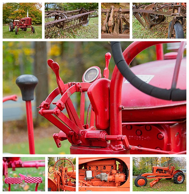
While driving through the countryside in Vermont, we passed by a couple of old tractors and other old farm equipment sitting in a small field. They looked intriguing as possible foreground for shooting star trails, as this was a scene we had expected to find more often in New England. Above are a few images we collected in the short time we stopped here.
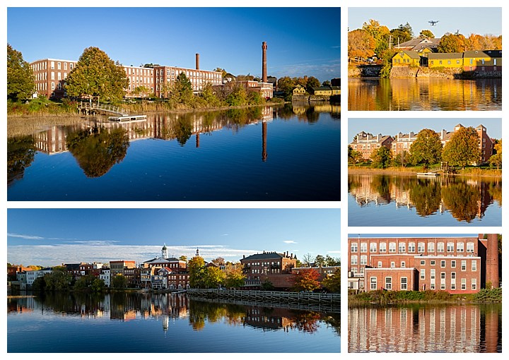
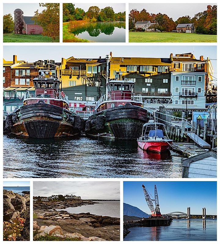
We were also introduced to an old textile mill that has been converted into offices in Exeter, New Hampshire. It sits on a river that was absolutely clear and mirrored when we arrived. I quickly sent up my drone (which has been getting a lot of use on this trip!), and got images such as the two on the left above. Upper-right is a photo Evelyn took of the drone collecting still other shots.
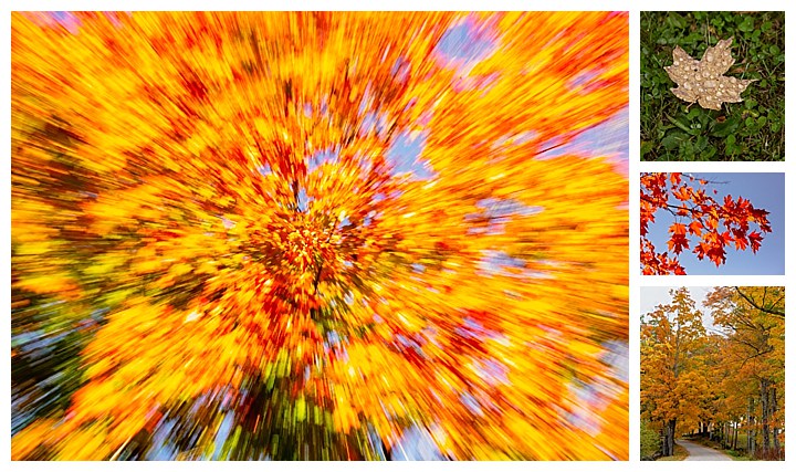
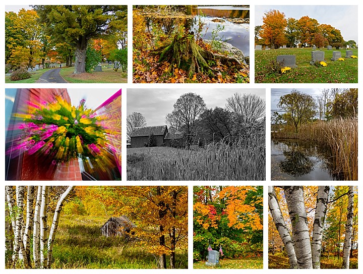
The primary target for this trip was to see the Fall Colors in New England, so we kept driving to places where the colors were turning, or preferably at “peak.” Above are just a few of the random images from that search.
The New Hampshire coastline was a treat, with its wonderful seafood restaurants. A favorite was Petey’s, outside of Portsmouth, with the best haddock and scallop ever. We were staying with friends M and T, whom we met in Ecuador a couple years ago. They made the most scrumptious chuck steak ever grilled over a tile on their barbecue. As much as we searched, we never found anywhere else that made steaks as good as these friends did!
Here is a two minute example of the glass blowing shop that we visited.
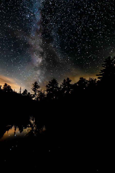
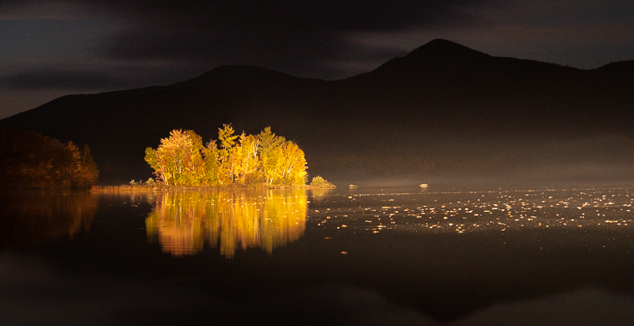
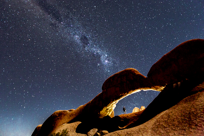
Despite the pastoral farms and seemingly endless rolling hills, Vermont has several dense, spread out cities and towns, and it is hard to find truly dark skies, as needed for good star photography. A few feet from where we photographed the light-painted island yesterday, there was a partially shielded area that allowed us to capture this image of the Milky Way. The light along the horizon is from a city some 50 miles away.
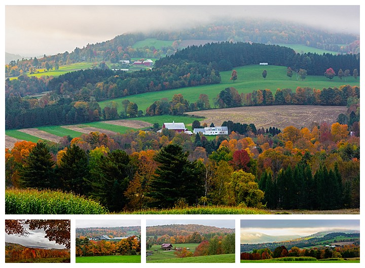
Vermont has many farms sprawling across rolling hills. In the Fall, after the harvest has been brought in, and before the leaves have left the trees, the scenes are postcard perfect for photographs. Vermont has a lower population density than the all but two states in the US at 68 per square mile.
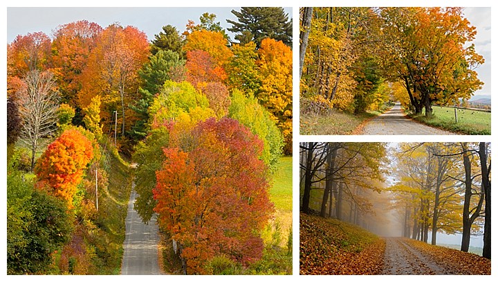
Many of the roads are lined with trees, and are also splendid in their Fall Colors. Even fog enhances the mood of the fall foliage. We like that Vermont has laws forbidding billboards, so the natural landscapes are preserved.
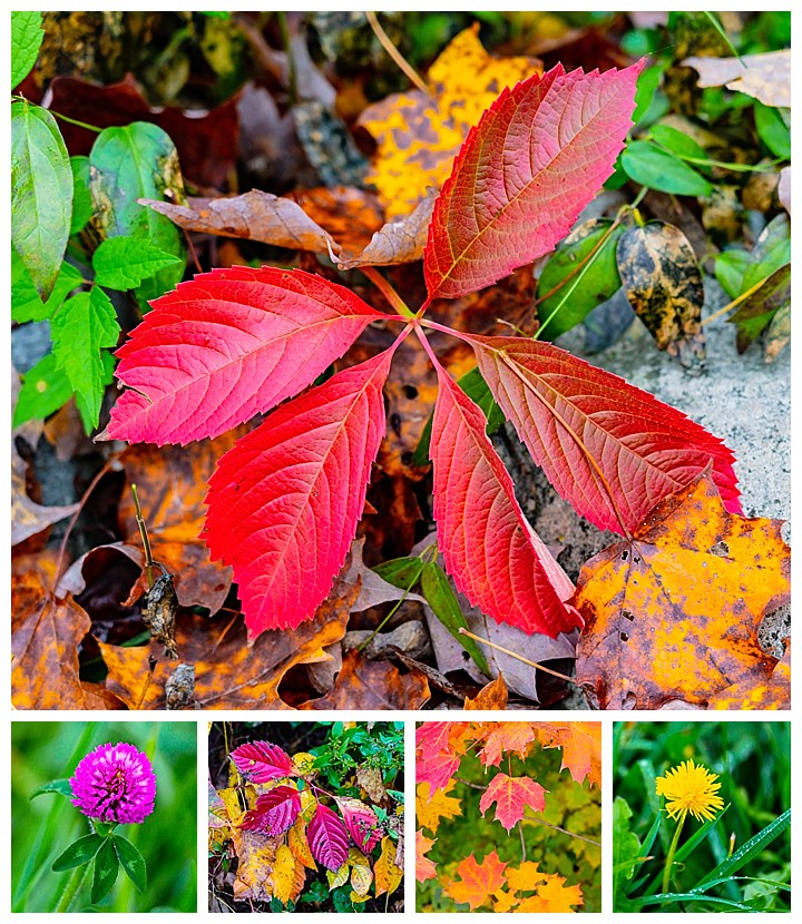
Be sure to look closer at the details, which are often overlooked when enjoying the wider colorful scenery.
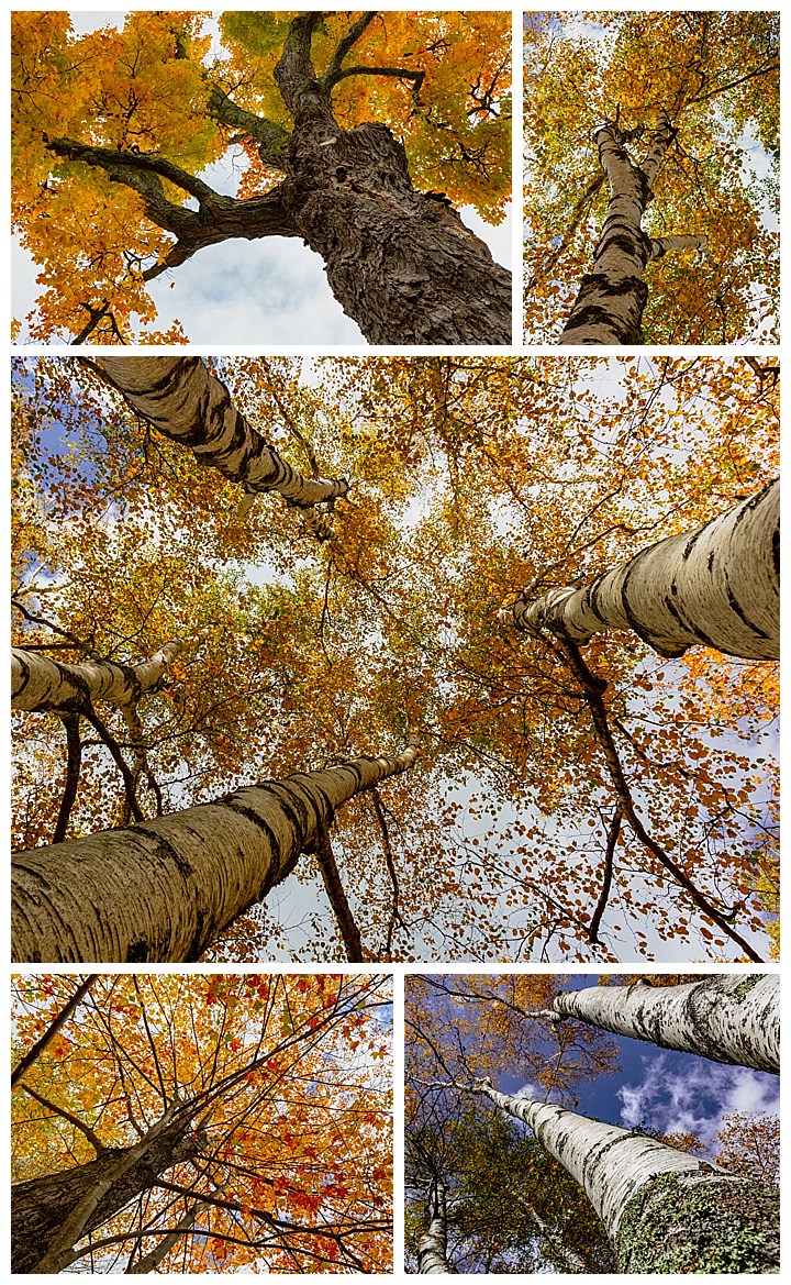
And don’t forget to look up too, for the patterns.
Some scenes are filled with texture, especially after the leaves have dropped. We are amazed at how quickly the peak colors disappear. Within days of Peak Color, leaves drop and the the scenes are muted again. The colors particularly pop whenever the sun shines through on a cloudy day, and you then have only moments to capture that vibrant color.
Photographers come from around the world to capture these scenes. We are fortunate to have been able to capture the fall foliage at its peak this year. We were surprised just how much we liked Vermont in general. No sales tax meant you actually paid what was marked on the merchandise. The local people often still leave their doors unlocked (something I didn’t know still existed in the States since the 1950s). Oh, and the food! We ate at “general stores” for lunch through most of Vermont, and we never had a bad meal. Some were just plain fantastic — such as the burgers at Worthy Kitchen in Woodstock.
Here is a short view of what the Fall Colors looked like from my drone flights during the workshop.
Seeing the Fall Colors in New England has been on our travel list for years. We decided to go this year, which was precipitated by my camera falling onto a granite rock during a windstorm in Namibia in July. That required it to be sent to the Sony repair facility (who fixed it under warranty!), but we cannot reliably ship such things to Ecuador. Coming to New England let us pick up the repaired camera, and experience the Fall foliage at the same time.
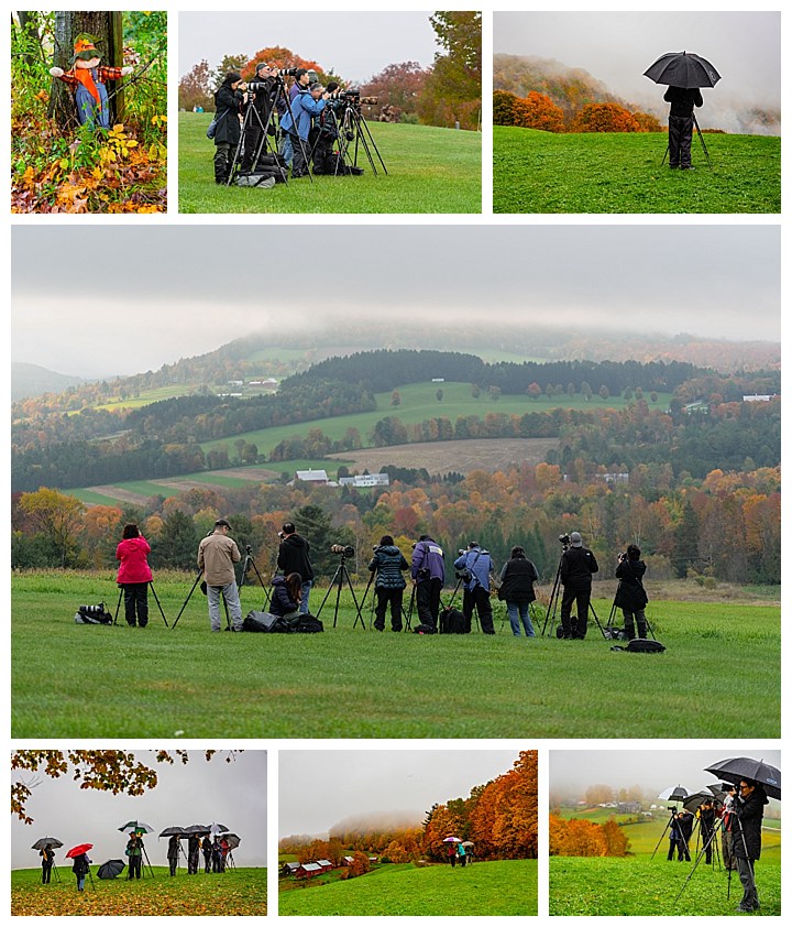
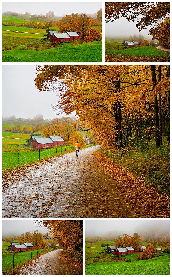
Since we were coming here, but did not really know the area, we decided to join a Vermont Fall Color Photography workshop with Loren Fisher. The timing of the Fall colors is always fickle, and you can never really tell just when the leaves will hit peak color. We were really lucky this year, and the workshop was right during Peak Color in Woodstock, Vermont, giving us ample opportunities to photograph the vivid display all week. Woodstock is considered one of the prettiest towns in the US, with pastoral and scenic photo opportunities everywhere you look.
Loren was a fantastic tour leader, able to answer pretty much all questions, and patient enough to do so. He was also very flexible, both of the vagaries of weather (we did have one nasty day during the week), and do requests from the group. For example, the image on top here is the result of the group asking him to return to this location after dark. He quickly adjusted plans and brought us back for images like this. (We will be traveling with Loren again to Chile next year, so this isn’t the last you will hear from us about him.)
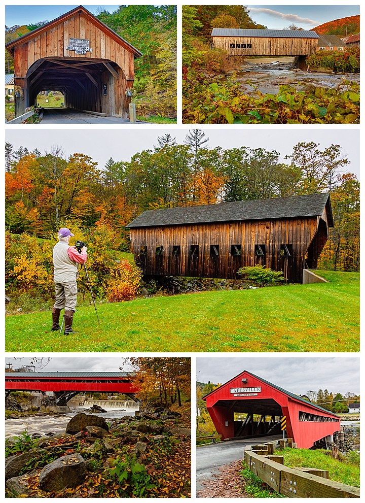
Covered bridges are one of the symbols associated with New England. Some of these bridges are hundreds of years old, with the cover intended to protect the wooden timbers from the Winter snow. Most have been renovated several times during their lives, some keeping with the original design closer than others.
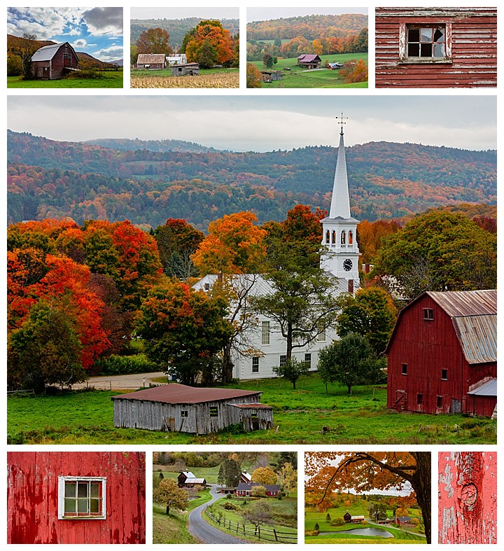
Red barns, general stores and churches are other symbols that come to mind in New England — sometimes combined, as in middle image adobe.
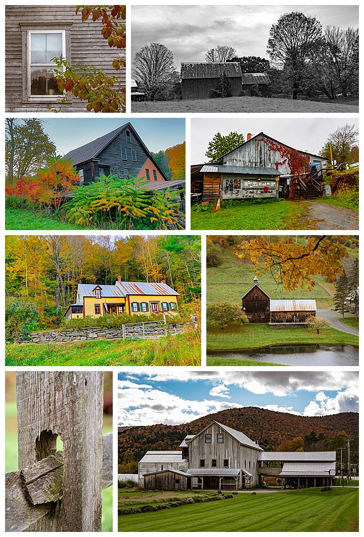
Not all farm buildings are red though. In fact, one common sight is unpainted buildings, which are designed to gain a patina from the weathering of the raw wood over time.
Many locations provide numerous chances for different photographs around the property. One example is Jenne’s Farm. All the images in the block above are from the same farm. We were there on the one rainy and foggy day this week. Some day we will likely return there during a sunny day… or a snowy day. Those would provide entirely different images from the same plot of land. This is sometimes referred to as “The most photographed farm in America,” having starred in Forest Gump and Funny Farm, plus being on the cover of Time Magazine.
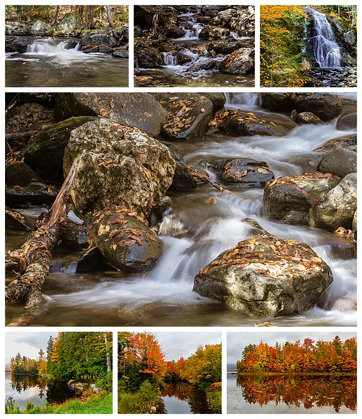
Water is everywhere in Vermont, which means lots of rivers, waterfalls, ponds and lakes. We learned that the difference between a pond and a lake is that you can see the bottom of a pond.
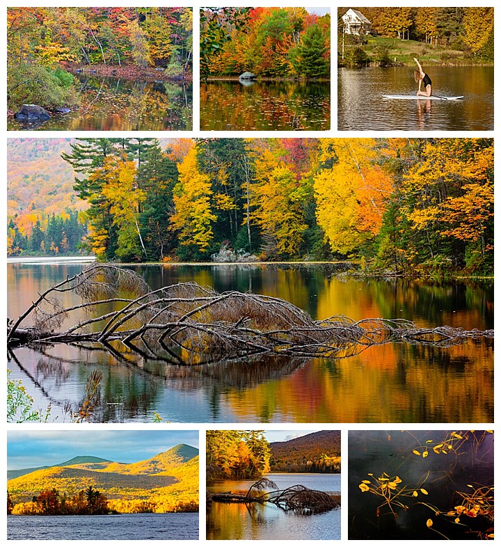
Lakes are numerous in the area, and many provide photogenic scenes with the Fall Colors surrounding them. Leffert’s Pond was one of our favorites. At one point, we met a woman who teaches yoga on a paddle board, who asked us to photograph her (upper right).
Here is an 80 second view of what it looks like to drive the roads of Vermont during Peak Colors.
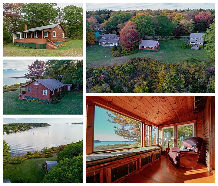
We just finished spending several days at a cottage on Chebeague Island, (pronounced Cha-beeg) just off Portland, Maine. We told some friends in Cuenca that we were going to spend a month in New England chasing the Fall Foliage colors. They said they had a cottage on this island that was available, and asked if we wanted to use it for a few days. We jumped at the chance to experience this part of New England!
The island is only 1 mile X 3 miles, and is the largest island in Casco Bay not connected to the mainland by bridge (the idea to create a bridge was floated, but soundly voted down in 1970). The island has an official population in the 2010 census of 340 people — with astounding growth to an estimated 346 by 2014! ☺
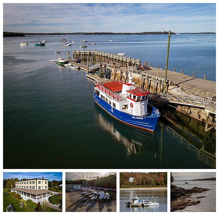
The panorama above is shot from the Casco Bay ferry landing, showing the jut of land on which our friend’s cottage sits. Theirs is a small red building in the middle of that row of half a dozen buildings (can’t be readily seen at this resolution, though it shows up nicely in a full size print).
The cottage appears to be a small unimposing log cabin from the road. Enter though, and it is spacious and very comfortable, with one of the best views from the island. Lower-right shows a scene from the sitting area on the harbor side, which was part of a recent remodel. The cottage is shown in the other photographs, including drone images of the property (upper-right and lower-left).
It is easy to drive the full circumference of the small island in under an hour. There are two ferry lines that go to the island; the ferries (upper) are lifelines to the mainland, and arrive every few hours all day long. If you want full groceries (beyond what is available at the small country store on the island), you can order it from Whole Foods on-line, and this ferry will deliver your groceries to the island!
There is only one hotel in town — the Chebeague Inn, shown lower-right. The food here is extremely good, and we ended up eating there three times in our four days here. The island, along with the hotel, shuts down mid- October, and reopens the following spring.
There are no taxis, so our friends loaned us their “island car”, which has no license plates. Keys were left in the unlocked car at the ferry landing, and the cottage was also left unlocked. We had forgotten that there are places in the world that are safe enough to leave doors unlocked. The gas station is a single unmarked pump at the dock.
There is also a boat dry dock (lower-second-from-left) on the island, where many residents store their boats for the winter.
And, of course, being a small island, water is always a major part of life (bottom-right two images). Chebeague Island has a small town feel, and it is easy to kick back and relax.
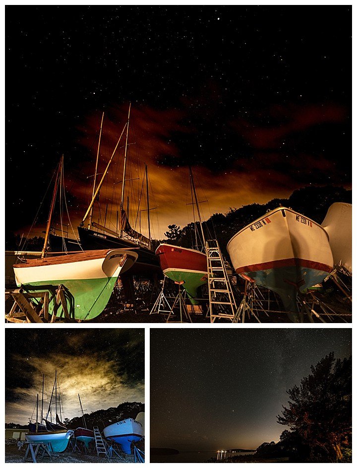
We timed this trip to catch the Fall Foliage colors. We were a bit early on the island, and this time of year tends to have mostly cloudy days. As such, our attempts at nighttime star photography was only marginally successful, The upper and lower-left images show how pervasive the clouds were. The clouds not only block the stars, but they also reflect the light from the nearest city — Portland,Maine in this case.
Here is a short one minute video (sans music) showing the island hotel and activity around the ferry dock.
How do you like my new profile image? My mother often described me this way when I was younger. Seriously… I’m thinking about using it… ☺
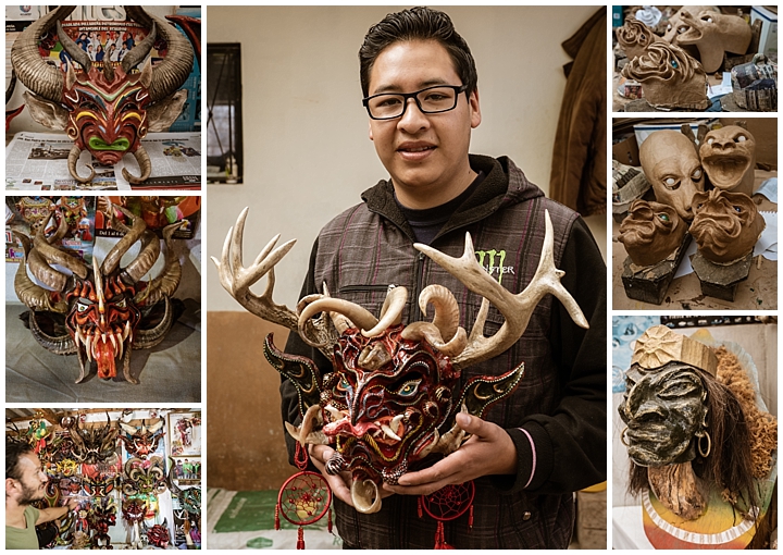
The day after we attended the Mama Negra festival in Latacunga, we headed towards Baños de Agua Santa, Ecuador. Enroute we stopped at a taller (workshop) specializing in making paper mâché masks for the annual devil’s parade in January. We didn’t really expect to be too excited about Yet-Another-Mask, but these really caught both our fancies. We ended up buying three of them! Esteban Arevalo struck gold again, by taking us to a place we would not have even visited on our own — and that we fell in love with!
The workshop, Máscaras de la Diablada Pillareña Velasco, is rather small, but filled with the most amazing devil / demon masks you can imagine. Luis is the master craftsman behind all of them, which has been part of a family tradition. All the masks are made of paper mâché, with authentic and elaborate horns, feel quite durable and ready to stand up to extended dancing at the parade.
Ours will find places on our walls, with two to be brought down annually for Halloween parties. We finally have a mask suitable for such occasions! ☺
The shop has more varieties of devils, demons, and even leprechauns. Yes, there are tales of leprechauns in Ecuador. To top it off, Luis will customize any mask for you, sized for your face (or wall) and with any design or color variation you want within two weeks of your order.
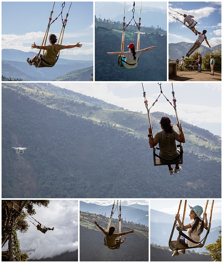
After leaving the shop, we went to Baños and checked into our hotel. We then quickly made a bee-line to the swings at “Casa de los Árboles” (Tree House). We took turns swinging over the abyss below, and of course, throwing our arms wide to demonstrate our hands-free balance. I was practicing videoing Esteban with my drone (center photo). There was one young girl also giving it a try, and always looking back to her father for a cell phone photo op (lower-right).
At one point, the unofficial “aerodynamic engineer” (a staff member) provided some extreme and fanciful assists to help us swing higher (upper right). He became a sight to watch all by himself.
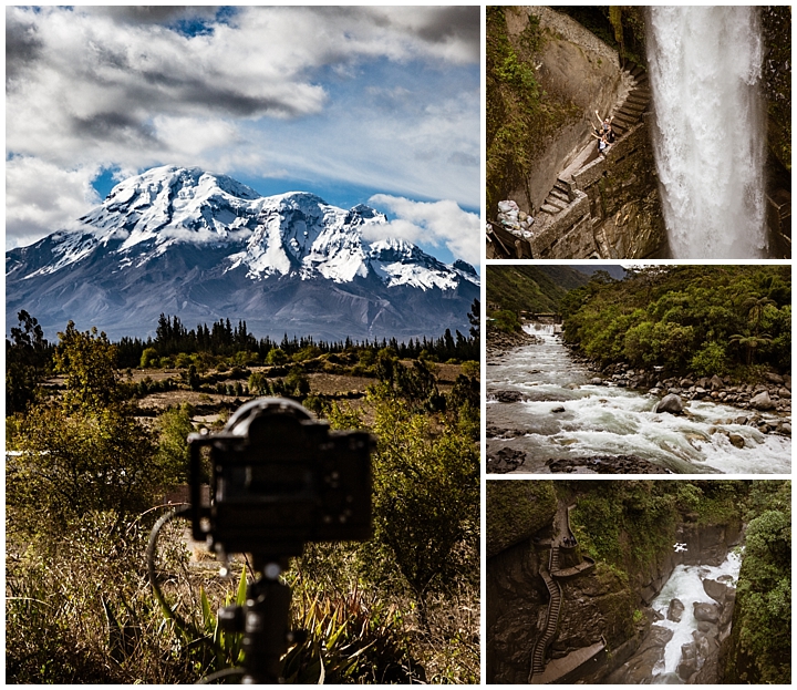
After we caught our collective breaths and teetered down the path to the car, we headed towards the Pailon del Diablo waterfall (Devil’s Cauldron). There are stairs that lead down to the base of the stairs from two directions, and never the twain shall meet. Turns out each is owned by a different owner and they are feuding, so the two stairs do not meet. The most elaborate and famous is the one seen in the upper-right and lower-right images. I flew the drone here for half an hour (one battery charge), then we headed back to Cuenca.
On the way home though, we saw that the Chimborazo volcano was clear of clouds. That is very unusual, since the mountain is usually completely shrouded. We pulled over to the side, where Evelyn shot the image on the left above (my camera is seen mounted on the tripod, creating a time lapse of Chimborazo).
To cross the chasm to the lookout where I flew the drone to video the waterfall, we had to go over a wooden suspension bridge. Here Evelyn is crossing the river.
Here is the result of the time-lapse created from 900 images shot over the space of an hour.
We have heard of the famous Mama Negra festival in Latacunga for years. This year Esteban Arevalo was setting up a trip to visit, so we jumped at the chance. As it turned out, we were the only two taking him up on the trip. Esteban took just the two of us as a result, and we ended up with a private guided tour. This turned out to be perfect, as we were able to stop for photographs whenever we wanted, and Esteban gave us far more background information on what was going on, and where, than we could have possibly gotten on our own. If you ever want to go to some authentic local festival in Ecuador (and beyond, it turns out), then we highly recommend contacting him to see what he can organize for you. Use this link for his email address.
The history of the Mama Negra festival is actually rather complex and fascinating. Rather than my explaining it all here, I strongly recommend you look at the Wikipedia page for the details. The brief story though, is that Cotopaxi (the nearby volcano) was erupting in 1742 and threatened the town. One black slave went to the mountain and prayed for salvation of the town. When the volcano eruptions ceased, the black slave became celebrated as the Black Mama. …or at least that is one of three competing origin stories for this festival. It happens to be the one I like best… ☺
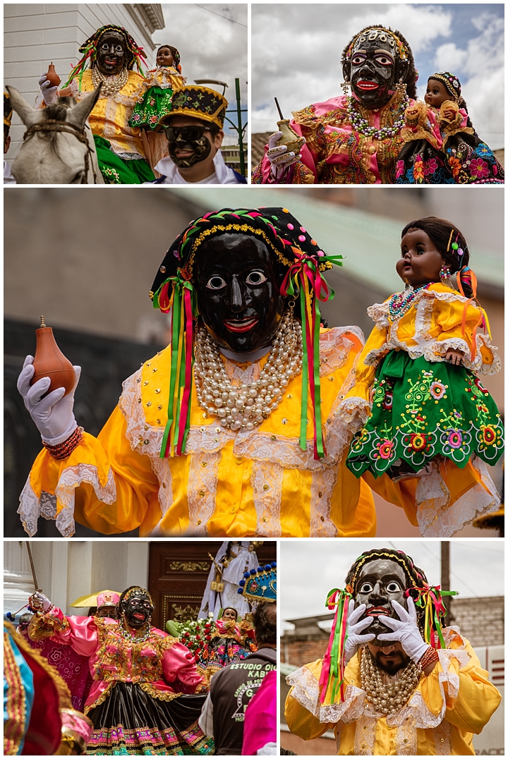
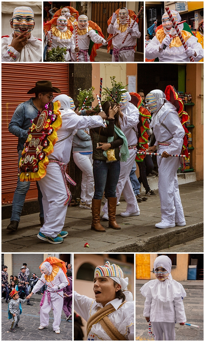
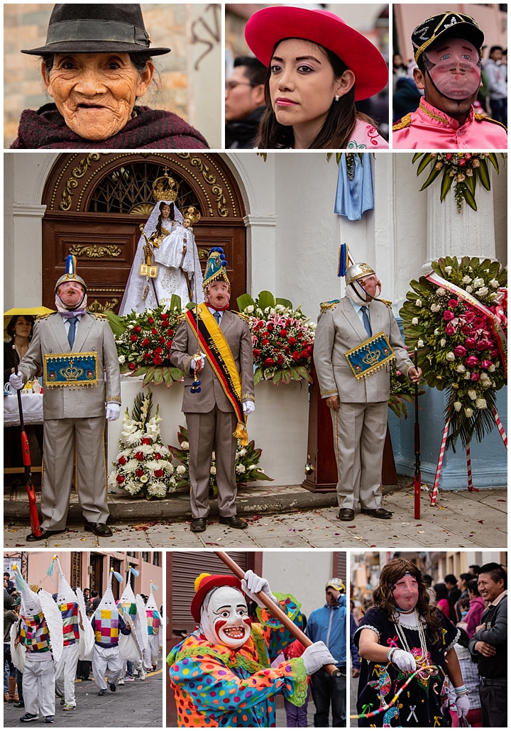
The festival is actually celebrated on three different dates in Latacunga. Don’t ask. Too complicated to get into, but the Wikipedia is a start if you really want to know why. We went to the September 24th celebration, which is the first for the year. In this celebration, there are “many Black Mamas” (three for this parade) and they wear masks, as seen above. Each is the Black Mama for a different neighborhood, and their accompanying marching group.
This festival continues for two days. The parade starts at 9AM on September 24th. At 1PM, everyone stops and goes to lunch. At 4PM, they return to wherever they were at 1PM and start again! This goes on well into the evening, by which time many in the audience are totally drunk, as this seems to be an excuse for the whole town to party… It then starts again the next day.
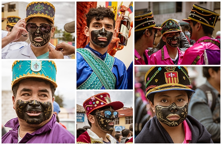
Those people accompanying the Black Mamas, as well as those with the ashangueros (more on them later) have only the lower portion of their faces painted black. They often also have other gold adornments in the paint, as seen above. When we asked why that was, we were told that painting the entire face black was too much work. I think they might have been pulling our leg though, since it was so universal and consistent. If anyone knows the actual symbolism here, I would love to hear about it.
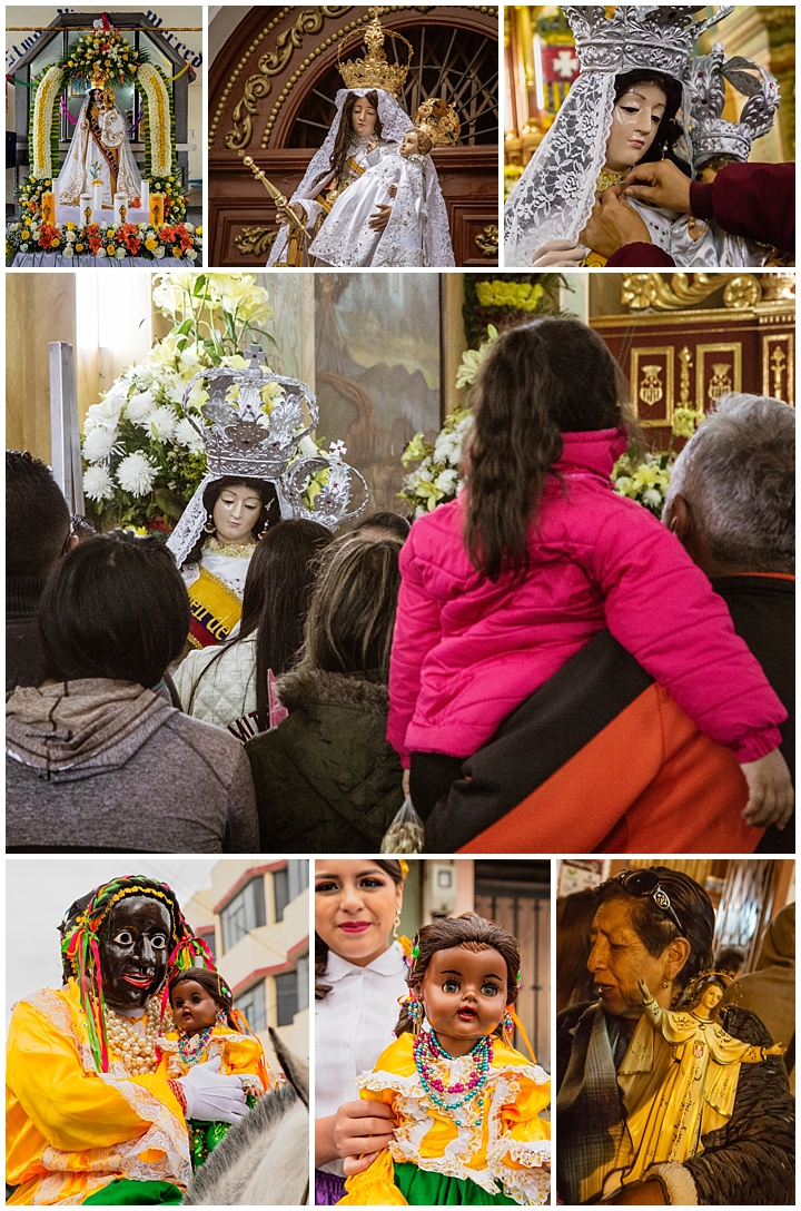
The Virgen de las Mercedes (Virgin of Mercedes) represents the saint that was prayed to for salvation from the volcano in 1742. It is featured prominently in church displays (top half images above), at the local mercado, and with the faithful carrying their own versions in the procession (lower-right). There are also plenty of black dolls representing the black slave that the faithful believe saved the town through her prayers (lower-left and lower-center).
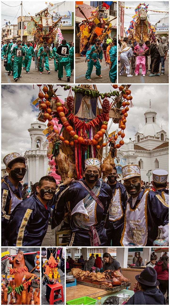
The ashanguero are the standouts of this parade. Only the strongest men need apply, since they must carry a full pig, adorned with all the extras needed for a feast at the end of the celebration. That means strings of fruit, plus several cuy (guinea pigs), and up to ten bottles of liquor. The upper-right image shows the ashanguero’s friends helping him adjust the straps on this load that can weigh between 250 and 300 pounds. There is always someone following close behind with a short table that the ashanguero can use to rest his load on. Every few blocks, the honor of carrying the load shifts to another person in the team, so one person is not carrying the load the entire time. At the end of the parade is a feast for the parade participants.
We also saw two little boys in the parade acting as ashanguero by carrying foam rubber pigs (bottom-center). While the parade is going on, with the pigs being carried down the streets, there were plenty of pigs already cooked and being eaten by the audience (lower-right).
Another important character in this celebration is the Huaco, or sorcerer. They wear paper mâché masks with horizontal colors over them, and carry similarly colored sticks, as seen above. They roam the parade route, picking out audience members to be cleansed of their evil spirits. Once singled out, 3 or 4 Huacos swarm over the the audience member, waving their sticks and mumbling incantations (center). When complete (takes about 10 seconds), the person is cleansed of all evil spirits… and of course is expected to tip the Huacos for the service they have performed… ☺
This is a festival that primarily involves adults. However, there were a few children involved too. The center image above shows one Angel de la Estrella, representing the Archangel Gabriel. When he reaches a concentration of people, it is his responsibility to recite “praise the virgin.” Each collective group with a ashanguero will also have an angel. We found it surprising how many of the children here were covering their ears because of the high volume of the constant music and rockets.
Music and dancing always play a large role in any festival or parade in Ecuador, and this was no exception. Each group had their own band, and their own dancers. I found it interesting though that every group played the exact same tune in this parade. If you stood with the leaving group on your right and the arriving group on your left, it seemed you could hear the music in stereo!
There were several other standard characters in the parade too, each having their place in the religious story of the festival. “The Shirt” (lower-right) is a man dressed in drag, who carries candy to give to the children. “The Clown” (lower-center) waves a flag ahead of the dancers, and his role is to attract attention to the group following. “The Captain” (center) is elegantly garbed with a sword in one hand, and is presented with fealty by each of the groups throughout the celebration. I never did find who the people in pointed white hats (bottom-left) were supposed to represent, and there was only one group of them in the entire parade line.
Many of the parade members wore transparent white(ish) masks (top-right and bottom-right). We were told that they represent the white slave-owners. When I asked why they would be celebrated, I was told it was a farce, making fun of those owners, but also allowing the parade member to do whatever he wanted, without repercussions — just as the white overlords were able to do in the 18th century. (I am not quite sure if I buy that explanation, but it is the best I could find in my research)
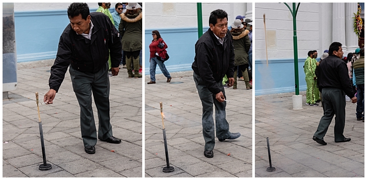
As with every celebration in Ecuador, there were rockets being fired at frequent intervals. Here is one man who lit off a dozen in as many minutes. He had a small tube with base that he put his rockets in. He then lit the fuse with a cigarette (left). Once it caught, he turned and walked slowly away (middle). The rocket would fire (right), explode in the air, and the process would start again.
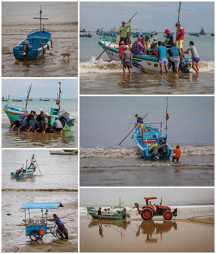
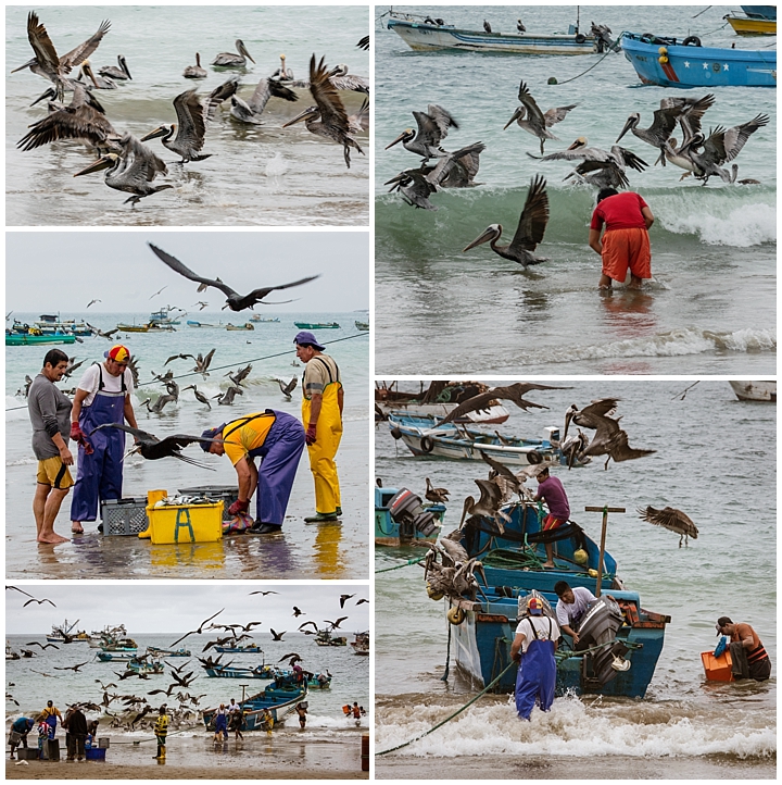
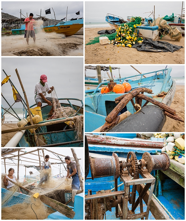
While we were at the coast, we took a couple drives to neighboring towns. We have enjoyed watching the fishermen come in with their catches in the past. We got started a bit late this time, and most of the fishermen had already sold their catch. This gave us the chance to see how they stored their boats and nets. A few years ago, we saw men putting their boats on logs and then pulling the boats up onto the beach for overnight. Now they use a tractor (lower-right) that hauls the boats well out of reach of high tide.
We did not get any photos of birds robbing fish from the runners carrying bins from the boats to the waiting trucks this time. The runners have gotten smarter, and now cover their bins with a tarp, putting the fish out of reach of the birds. That doesn’t mean there were no birds though. There were hundreds of pelicans, frigates and seagulls swarming and swimming. They would grab fish from the boats themselves (lower-left and lower-right), or from fishermen sorting their catch to take home (middle-left). When a fisherman would walk into the surf to clean out a bag or bucket, the birds swarmed for any remnants too (upper-right).
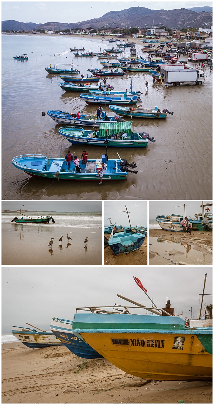
There were dozens of small fishing boats lined up on the beach (upper image, shot from a drone, and bottom image shot from ground). Though all the boats were actively used, many looked to be pretty battered (middle).
After the boats have been safely hauled up onto the beach, the fishermen tend to their nets. We walked along the coast in San Pedro to watch them straighten out the nets (upper-left and lower-left), and repair them (middle-left). The fishermen were all very friendly towards us, though most just went along with their daily work.
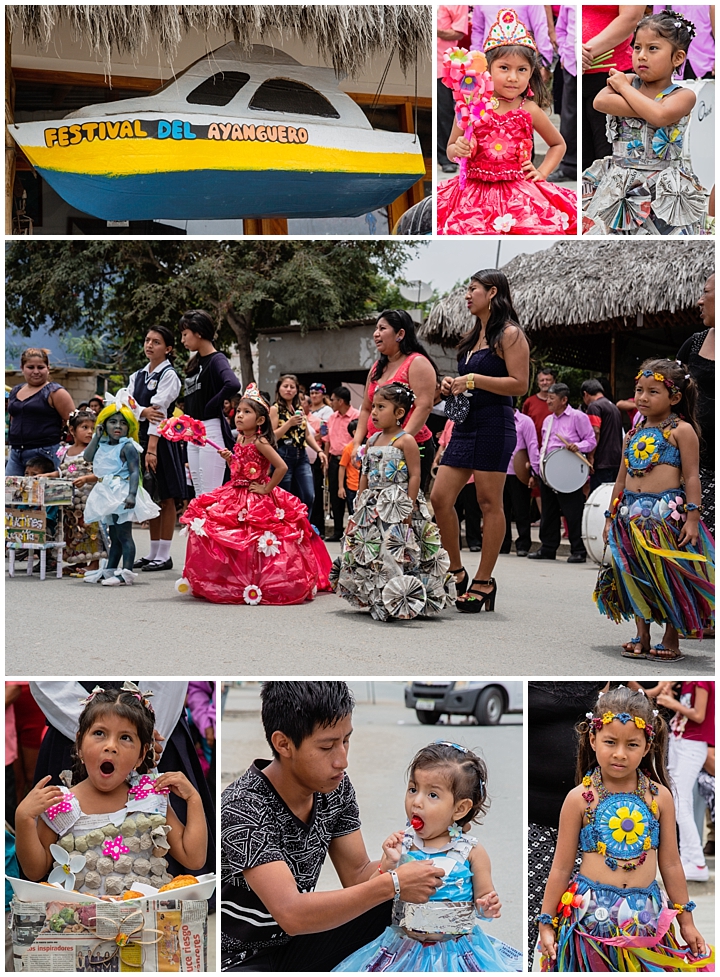
At one point, we decided to take a detour into Ayanguero for lunch. We found our way blocked by a tiny parade, so parked and went to watch. We found ourselves next to the reviewing stand, where the speaker loved to talk on and on… and on… It turned out this was a children’s costume contest for 1st grade girls. Kids that age are always fun to watch, but in this case it was pretty clear they were all pretty bored by the whole scene. The parents seemed excited to show off their daughters (middle), but the kids just wanted to get it over with.
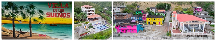
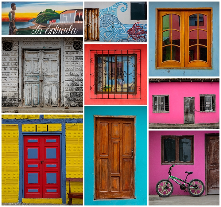
We hadn’t been to the Ecuador coast in a couple years. Also, we have plans for October where I will be using my drone quite a lot, and was looking forward to practicing in open, unobstructed spaces rather than the confined streets of Cuenca. We therefore decided it was time to take a few days on the coast, both to explore, and to give me a chance to practice my drone flying.
We opted for Villa de los Suenos (“villa of dreams”) in a tiny village called La Entrada. We rented the penthouse, which allowed me to fly from the terrace of our room. The Villa is a Bed & Breakfast, seen above in the center image. Though very isolated, making us glad we had a rental car, it was also very comfortable. The owners, Shell and Marsha Spivey are extremely friendly and went out of their way to make us feel welcome, including driving us to dinner in a hole-in-the-wall seafood restaurant on the beach, a half hour drive North. We would have never found that on our own, and the food was absolutely delicious (as was pretty much every meal we had on this trip). This bed and breakfast has received 97% 5-star ratings (with the rest all being 4-star) on TripAdvisor, and it is easy to see why.
Shell and Marsha, the owners of the Villa, have worked intensively with the locals to promote tourism for their village. Their goal has been to create a destination art community, with colorful facades and art & music festivals in the future. One major project that was just completed is an exceptional church, with a floor-to-ceiling glass wall facing the ocean (rightmost image). In addition to providing spiritual guidance to the people, it is also intended to become a location for destination weddings, and thus source of income for the village.
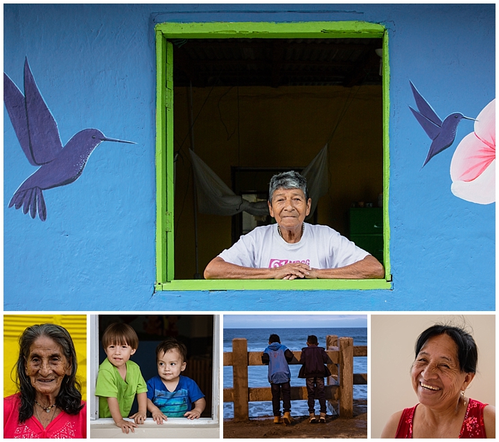
One afternoon, Shell gave us a tour of the adjacent village of La Entrada. With him at our side, the residents were welcoming, and even posed for our cameras in better light. In a town with a population of only a few hundred, they have a pre-school and center for learning to make jewelry. They are looking for artists to teach the residents how to create their own quality artistic micro-businesses.
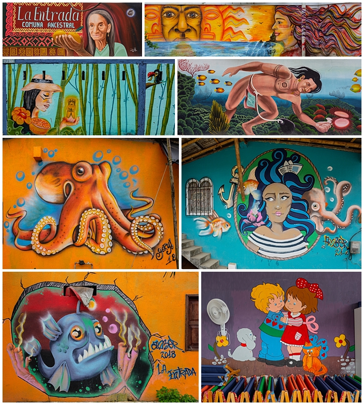
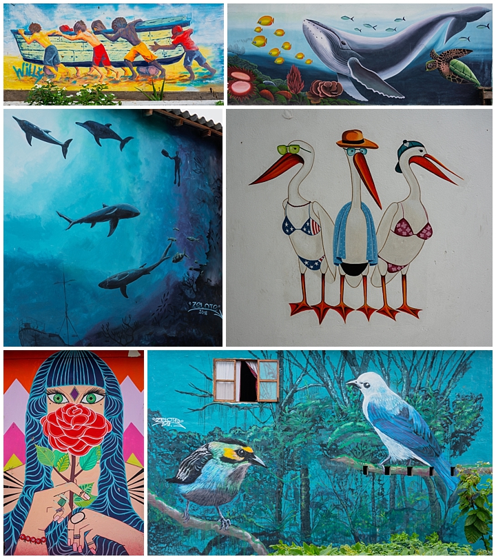
Shell and Marsha arranged for artists from around the country to come and paint giant murals throughout the village. Most are in excellent condition, having only been painting a few months ago. The mural lower-right was in the school library. There is another upcoming mural project in the next few months, with walls already designated for artists. The village wants to exchange ocean-front rooms for prospective artists.
Everywhere you turned in town was another mural. It is worth a visit to this tiny village if only to see the murals and colorful facades on display. Many of the facades have just been painted in the last year.
Shell and Marsha have also pushed a volunteer effort to paint all 128 homes in the village — on all four sides (it is customary in Ecuador to only paint the front and back, and ignore the sides). The town has gotten 50% discounts on paint, and many other donations. Each home owner is required to actually paint his own home, which assures that they have a vested interest in the results.
The photo galleries for the recent trip to Africa have now been posted. You can reach them by going to the menu at the top of every page and choosing Travel, then 2018. You can optionally go directly to each of the four galleries by choosing that from the 2018 submenu too.
Or just click here to go to the selection page for all 2018 travel (so far…)!
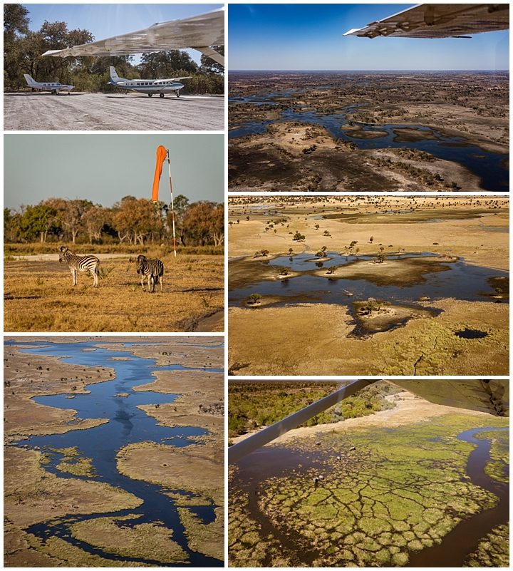
Our final campsite was in the Okavango Delta, a rich swampy inland delta produced by seasonal flooding. The waters evaporate and transpire, but do not empty into the sea. This wetlands area, including the Moremi Reserve, has been designated as a Unesco World Heritage site. During the wet season, much of the area we drove is under water. In October, thousands of zebras populate this area. The temperatures frequently exceed 40 degrees centigrade (105 deg fahrenheit) during this period.
In order to reach that camp, we needed to fly in small planes reminiscent of those we owned and flew ourselves in the 1980s. We were warned that we might be in planes with as few as 6 seats, including the pilot, and that our luggage would be severely restricted to no more than 1o” X 14″ X 22″ in size, and no more than 35 pounds per person, which included the camera bags. The camera bags themselves each weighed more than 20 pounds each, leaving very little for clothes. That luggage restriction was the driving force for our buying new luggage (we didn’t have anything that small !), and then cutting and cutting contents until we fit within those limits.
We survived five weeks in Africa in three countries within those limits, even hauling two cameras each plus tripods, all lenses, and other photographic accessories. This was the “tough love” of travel packing, but we were both surprised how well we actually managed with so little. Of course, one of the things we had to leave behind was a shaver, so Burt ended up growing a beard. That beard remained after returning home, so maybe even that was a positive…? ☺
While we were waiting for our plane to arrive, we noticed a couple of zebras on the airstrip (middle left). We were told that the small planes always buzzed the field first to ensure there were no animals on the runway. Our jeeps also strategically placed themselves halfway down the air strip to drive off any animals that wandered into the airplane’s path.
As we flew from our Moremi Private Reserve camp to our final camp, we had a splendid view of the Okavango Delta from the air, as seen above. We were a little disappointed to not see more herds of animals on the inlets below, but even at our low altitude, those that were visible were too small to really make out (lower right).
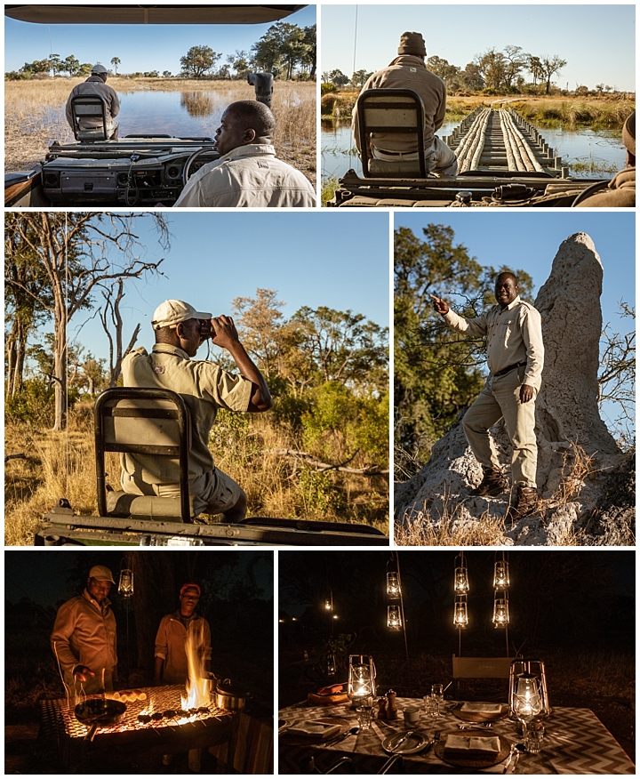
Normally we try to shoot a fair amount of “behind the scenes” images while we are traveling. As we arrived in our last Botswana camp, we realized that we had been so enthralled by the wildlife around us that we had neglected to do much of that this time, so we made a concerted effort to correct that oversight here. We were served on tables with white table cloth, metal utensils, wine, “candlelight” at every meal (lower right). While we were eating, we had our beds turned down with a hot water bottle in our beds.
Our Land Cruiser 4-wheel drive was a workhorse, as they always are in Africa. There were many places that we would have turned around had either of us been driving, but our guides just kept on going. The marsh (upper left) and rickety wooden bridge (upper right) are only two small examples.
The Land Cruiser has a seat for a wildlife-spotter on the front bumper that allows a tracker to help follow game or use the flood light to locate the game (middle left).
Sam (middle right) has been our driver and guide from the moment he picked us up on first day from Victoria Falls. His immense knowledge of the animal behavior, plants, general landscape, and his knowledge of photography, combined with his infectious humor has helped make this a very enjoyable week.
We knew that we were signing up for a camping trip (lodges are astronomically expensive, so this was a way to see the country without breaking the bank). Not entirely sure what to expect in camping, we were very pleasantly surprised at the quality of the food cooked on a camp stove (lower left), and totally astonished at the luxurious accomodations (lower right) that were available in the wild. Note though, that all the light is by kerosene lamp. The only electricity we had during the week was an inverter on the car battery — just barely enough to keep the camera batteries charged, and sometimes kept the computer alive long enough to download the images at night. Our tent nightstand lights were powered by batteries that were solar-driven.
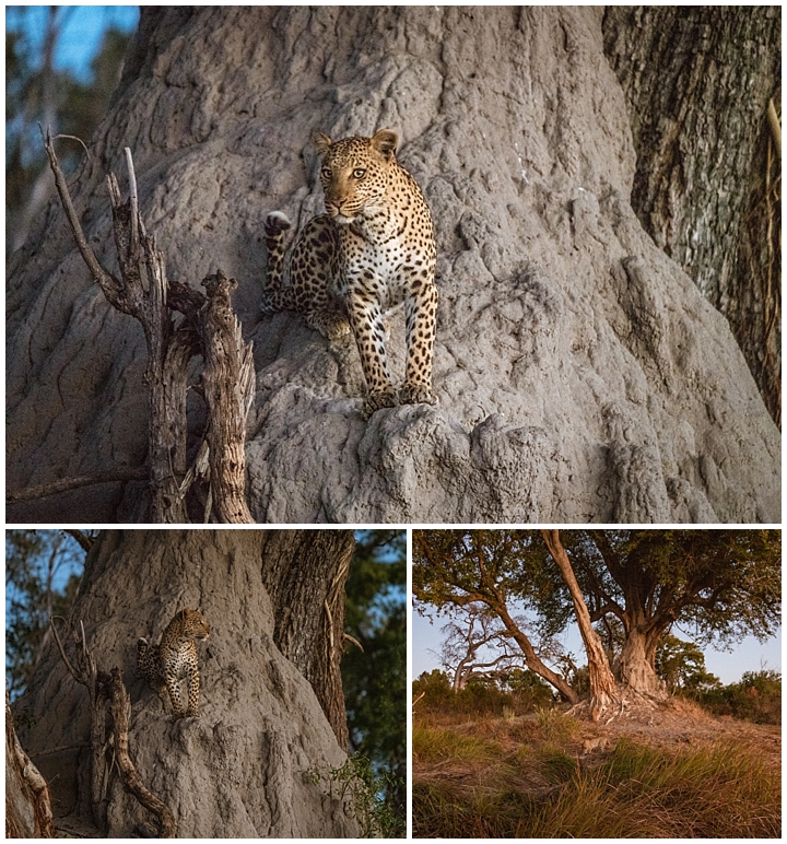
Sam had heard there was a female leopard with a new born baby, so we began tracking them the first day that we arrived. Just about when we had decided we would not see them in the wild, Sam and Equator (our spotter) found tracks in the sand and started to follow them. Not long later, we stopped, turned off the engine, and listened. We heard a sound in the distance that Sam identified as a leopard call (a low pitch, deep breathing moise, which sounded like a wart hog to our ears), and we were off on a chase to find it.
Turned out to be the female we were looking for. She apparently had lost a baby just a few days before, so was on the prowl again. After almost 2 days of searching, we found her partway up on a termite hill scanning the horizon for signs of her target. After a few minutes, she left her mount and started walking towards some unknown destination, where we quickly lost her in the brush (lower right).
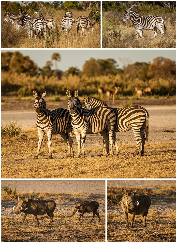
This was the second camp area rich in zebra, which are always a delight to see in the wild. We also saw some warthogs here. I heard a splashing sound while working on my laptop after lunch, when everyone else was taking a siesta. A warthog had walked out from the marshy water to within a few feet of me, and ran quickly away. Usually when warthogs run, their tails are held straight up. For some reason, this pair ran with their tails pointed straight behind them instead (lower left). Of course, as soon as they were out of camera range, the tails went vertical…
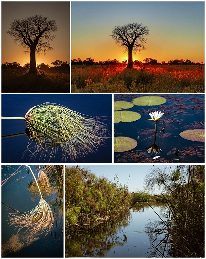
Being a marshland, we had a chance to see some of the watery canals in the delta. It is never possible to predict what wildlife will be visible at any time or place, and we happened to be out during a time with almost no animals visible, leaving us with only the images of the plant life rampant in the canals. Papyrus plants, historically used for making paper, lined the canal. We were told that elephants and hippos generally kept these canals clear. We did have two sightings of the rare SitatungaAntelope, which is one of the Okavango Delta’s most elusive inhabitants, and Sam told us we were extremely lucky.
As we left camp, the staff (Equador, Kay, Vincent and Mutengo) gathered with a farewell song. This particular camp was also our farewell to Botswana, as we departed Okavango Delta to fly to Johannesburg, and then the long (much longer than expected, due to delayed flights…) route back home to Cuenca, Ecuador.
Photo Galleries
At the top of this page is a menu that will take you to a variety of galleries showing our favorite images.